
 Naturae
2021 (26) - Pages 351-361
Naturae
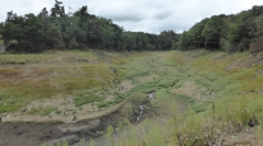
2021 (26) - Pages 351-361The restoration of the ecological continuity of the Sélune river is a management project of the French ministry of ecology that is removing two large hydroelectric dams (36 m high and 16 m high) and that is unprecedented in Europe. The scientific program includes an analysis of the spontaneous recolonization of the river margins of the neo-valley of Vezin after the lake disappeared (a length of 19 km and an area of 160 ha). The second downstream dam of la Roche-qui-Boit will be destroyed later, after the success of the first Vezin dam removal. The Sélune River is a 85 km long coastal river in Normandie (northwestern France). It flows from Saint-Cyr-du-Bailleul (elevation of 175 m) to the Bay of Mont Saint-Michel and the English Channel. This low-energy river has a mean annual discharge of 10 m3/s, which ranges from 3.1 m3/s in August to 20.2 m3/s in February on average. Its pluvial hydrological regime is characterized by winter floods. Its watershed of 1107 km² mainly occurs in rural areas caracterised by intensive farming (mixed crop-livestock farming and dairy farming) and agro-industrial activities. The climate of the region is temperate and hyperoceanic with an annual mean temperature of 12 °C. Although mean annual precipitations is 800 mm, the study year was a dry one (695 mm in 2017). The growing season lasts from April to September. The Sélune River has been greatly impacted by its two large hydroelectric dams built in the early 20th century : the Vezins dam located upstream (36 m high and 278 m wide) and the La Roche-qui-Boit dam located downstream (16 m high and 129 m wide). Although there was a period of conflict over the dismantling project, the dams are expected to be removed by 2019 and 2021 respectively. The Sélune River will flow continuously again, and both 25 km of the river channel and 181 ha of the river valley (the combined dimensions of the two reservoirs) could return to a more natural state. In the pre-removal period, a showcase engineering project focused on reservoir draining and sediment management (i.e., channel widening and in situ storage involving local-level riverbank profiling) has been conducted to avoid sediment erosion ; it was a response to environmental and societal issues, as well as concerns over cultural heritage, related to the presence of the Mont Saint-Michel. The Sélune project is thus employing both a “passive hydrological” approach and an “active geomorphic” restoration method. Successive levels of the emptying of the lake of Vezin have gradually exposed the sediment beaches of the neo-valley (2015-2018). The huge civil engineering works were performed in the river bed. A storage of sediments by localized reshaping of the banks allowed the prevention of erosive risk (potential removal of 700 000 m3 of mobilizable sediment). These sediments, which we want to block in the neo-valley, constitute pioneer environments opened to plant recolonization. The two years of monitoring (2017-2018) aimed to observe the spatial pattern and the trajectory of spontaneous plant communities from the structural, ecological and taxonomic points of view. The spontaneous plant communities of the neo-banks of the main course of the Sélune in the old dam lake (19 km by two banks, Strahler number 5) are different from those of the five main tributary streams of the neo-valley (a few hundred meters each within the new valley, Strahler numbers from 1 to 3). These small streams contribute to the recruitment of a spontaneous riparian flora different from that of the 38 km of banks of the main course of Sélune. These ecological engineering results reinforce the possibility of passive ecological restoration of the banks of the neo-valley, with the assurance of obtaining a mosaic of riparian habitats.