 Naturae
2019 (5) - Pages 113-164
Naturae
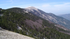
2019 (5) - Pages 113-164The Wilderness Area of Mount Ventoux is an example of a reforestation project in the Southern Alps, which was largely deforested in the mid-19th century but reforested since the ca. 1870s. Clearings, which have been practiced for centuries and the reforestation that followed, have shaped the vegetation, forming a patchwork composed of natural stands of beech and silver fir, plantations of local and exotic species, moors, rocks and screes. All vegetation formations have been mapped. By using numerous floristic surveys, we established a habitat map of the Mount-Ventoux reserve for the tree, shrub and herb layer (CORINE Biotope classification). The habitat survey presented here uses new methodology based on shared scientific repositories and recent tools, and, compared to the previous descriptions and mappings of the Mount-Ventoux vegetation, it reaches an unprecedented accuracy (map in 1:2500th scale). This mapping may be regarded as the first complete habitat map of the reserve. Our study showed that the reserve contains 25 different types of habitats including ten habitats considered to be of community interest. Forest formations and edaphic environments occupy almost all the space of the reserve leaving little space for shrublands and grasslands. For a half-century, habitats of the reserve have been transformed by numerous phenomena: fir dieback (due to increasingly severe climatic constraints), colonization of open environments by pioneer species, opening and closing of avalanche paths over the decades and development of natural regeneration under existing forest stands. These events have subsequently caused patterns in the vegetation, detected by our study, and will likely result in habitat evolution, leading to the extension of forest environments, plantation replacement by native formations (specifically beech trees) and the retraction of fir stands.From the pre-reforestation survey to the present day, studying the vegetation of the reserve using different methods makes it possible to trace their evolution in descriptive and cartographic form, over a period of 130 years. The synoptic view thus offered, hitherto unusual, improves the general knowledge of the vegetation of the Mount Ventoux.
Vegetation mappings, fir dieback, natural colonization, climatic change.
Permalink (to link this page)
http://revue-naturae.fr/2019/5